Hurricane Genevieve: The First Major Storm of the 2026 Season
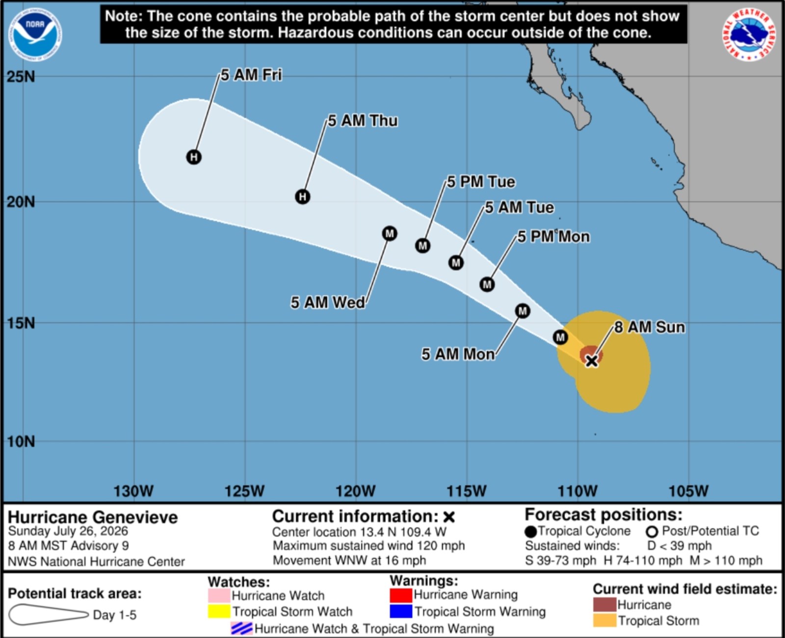
Hurricane Genevieve has become the first major hurricane of the 2026 Eastern Pacific season, achieving a significant milestone as the first major hurricane in either the Eastern Pacific or Atlantic basins this year. Meteorologists caution that the storm may intensify further, potentially reaching Category 4 status by Monday.
The National Hurricane Center (NHC) announced that Genevieve, currently a Category 3 hurricane, possesses maximum sustained winds of 120 miles per hour. Situated over the eastern Pacific Ocean, it is well southwest of Mexico. Though landfall is not anticipated, experts warned of possible strengthening in the next few days, with an expected weakening trend later in the week.
Alongside Genevieve, the NHC continues to monitor Hurricane Fausto, which poses a threat to Hawaii. Newsweek has contacted the NHC for further commentary.
Understanding Major Hurricanes
A major hurricane is classified as a Category 3, 4, or 5 storm on the Saffir-Simpson Hurricane Wind Scale (SSHWS). Such hurricanes sustain winds of at least 111 mph, potentially causing significant wind damage and coastal impacts near populated regions. Genevieve reached this milestone on Sunday after a period of rapid intensification.
During a Category 3 hurricane, substantial damage can occur if the storm nears land. According to the NHC, “devastating damage will occur.” Well-constructed framed homes may suffer major damage, including loss of roof decking and gable ends. Numerous roads could become blocked by snapped or uprooted trees, and electricity and water may be unavailable for several days or weeks.
Hurricane Genevieve’s Current Location
The NHC reported that Genevieve was approximately 515 miles southwest of Manzanillo, Mexico, on Sunday morning. The hurricane moved west-northwest at about 16 mph, with its minimum central pressure dropping to 963 millibars, indicating its intensified structure.
Tracking Hurricane Genevieve
Animated weather maps from windy.com depict Genevieve with strong winds off the coast of Mexico. Satellite images reveal a well-defined eye in the center of the hurricane. Despite its strength, the intense rainfall is expected to remain offshore throughout its duration.
Though landfall is not predicted, some coastal effects are anticipated. The NHC public advisory stated, “Swells generated by Genevieve are affecting portions of the southwestern coast of Mexico and will likely reach southern parts of the Baja California Peninsula by tonight or Monday.” These swells pose a threat of life-threatening surf and rip current conditions.
Forecast projections suggest Genevieve will continue over open waters, eventually meeting cooler sea surface temperatures and less favorable conditions, which will prompt its weakening. However, meteorologists expect Genevieve to uphold its major hurricane classification through at least Wednesday morning.
Genevieve’s notable appearance is the first among high-intensity storms for the 2026 season across North America’s principal basins, with the Atlantic currently experiencing a lull and no other active tropical cyclones under NHC’s observation.