Google Halts AI Feature for Satellite Image Generation
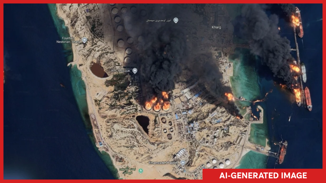
Recently, an AI-generated image portrayed several fires on Kharg Island, an Iranian site known for its vital oil terminal in the Persian Gulf. NPR generated and annotated this image. Mere days after Google introduced a tool on its Google Earth platform to create AI-generated satellite images, the company removed it. Google explained they saw professionals using the tool effectively, but also noted potential policy violations from shared imagery. Consequently, they decided to retract the feature while enhancing safety measures.
The original announcement highlighted the feature’s creative potential. Users simply needed to zoom in on Google Earth, click ‘create image,’ and type any imagined scenario. However, experts voiced concerns about possible misuse. It threatened those relying on satellite imagery for authenticating news and events globally. Henk van Ess, an open-source researcher, tested the tool’s limits by creating images depicting various fictitious events like refugees at the border and bombings in Gaza. NPR also tested and created false scenarios, including Kharg Island aflame and a submerged U.S. Capitol.
Journalists and investigators questioned Google’s decision. Evan Hill from The Washington Post critiqued the lack of internal review given the potential for widespread disinformation. Hill’s tweet highlighted the unchecked potential for abuse using AI-generated satellite imagery.
Satellite Imagery as a Truth Benchmark
As deepfakes proliferate, satellite images remain crucial for verifying the authenticity of events. Open-source investigators use these images to corroborate ground events and assess shared media. Although Google Earth doesn’t offer the latest images, its extensive coverage assists in cross-checking information against newer satellite visuals.
Jake Godin from Bellingcat emphasized the reliability of satellite imagery, noting their typical control by reputable entities and origin from tough-to-mimic cameras in space. Although fake satellite images have appeared before, like in the U.S.-Israel conflict featuring a U.S. base in Bahrain, they remain relatively rare.
Impact of Single-Click AI-Generated Images
Creating AI satellite images with one click threatens to increase fake images. Godin worried this ease might boost the spread of misinformation, which often outpaces corrections. He expressed concern that real satellite images may be dismissed as fake, eroding public trust.
Google has addressed misinformation concerns, stating that all AI-generated images carry a SynthID watermark, identifying fabrication in Google tools like Gemini. They also prevent creating images on harmful topics and pledge continual updates. Despite this, there is skepticism within the open-source community. Van Ess lamented that the feature might undermine Google Earth’s role as a trustworthy verification tool.