Satellite Images Reveal Lake Powell’s Dramatic Water Level Decline
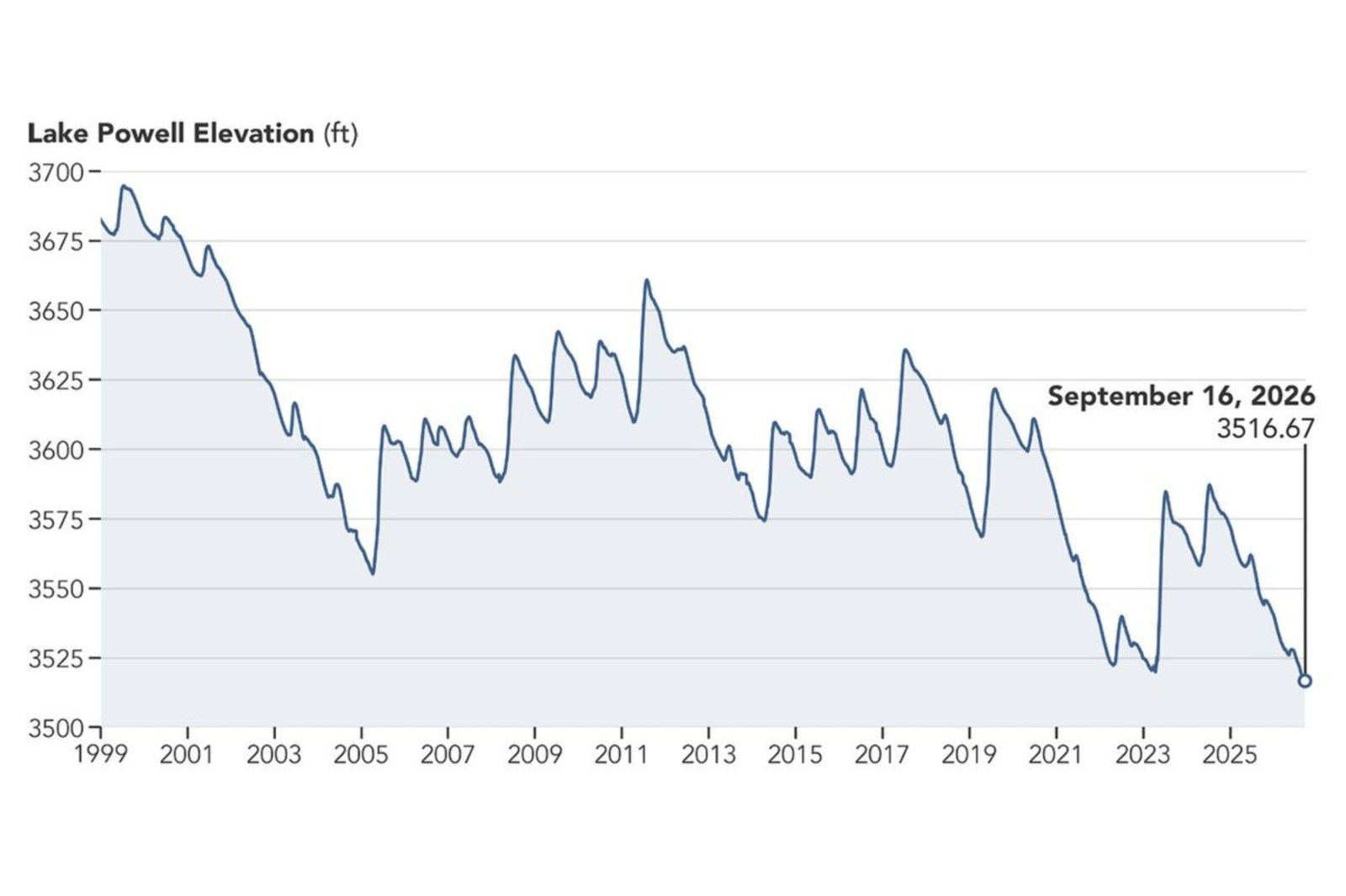
Recent satellite images reveal a dramatic reduction in Lake Powell’s water levels over nine years. These images compare the area near Glen Canyon Dam on September 1, 2017, with that of September 10, 2026. A prolonged drought has significantly contributed to the reservoir reaching its lowest recorded level.
According to NASA, the water level in 2017 was among the highest in the previous decade. However, the image from September 10, 2026, shows a stark decrease. At this time, Lake Powell’s water level stood at 3,517.24 feet, occurring roughly a month after falling below the previous record low of 3,519.92 feet set in April 2023.
Importance of Lake Powell and the Colorado River System
Lake Powell, the second-largest reservoir in the United States, is located along the drought-affected Colorado River. This river, spanning around 1,400 miles, is vital for seven states: Arizona, California, Colorado, Nevada, New Mexico, Utah, and Wyoming, as well as Mexico. It supplies municipal water to tens of millions and supports hydropower, recreation, fish, wildlife, and millions of acres of agricultural land.
Record Lows in Major Colorado River Reservoirs
NASA released these images shortly after both Lake Powell and Lake Mead reached record low levels in August. The Bureau of Reclamation, managing both reservoirs, attributed these lows to a record-low winter snowpack in the Colorado River Basin during 2025-2026.
Sarah Porter, director of the Kyl Center for Water Policy at Arizona State University, highlighted the seriousness of the situation. While the reservoirs may partially recover in the winter, Porter noted that levels have been decreasing over the last 25 years. One significant winter will not stabilize the entire system long-term.
In response, federal water managers announced several measures in April to support Lake Powell’s decreasing levels. These included releasing water from the upstream Flaming Gorge Reservoir and reducing releases from Lake Powell downstream to Lake Mead. The Bureau of Reclamation cautioned that, without significant intervention, the Glen Canyon Dam’s hydropower production could be at risk.
Projections for Lake Powell’s Future
New federal projections suggest that Lake Powell’s water level might increase by about 40 feet over the next two years. The Bureau of Reclamation’s September 2026 “most probable” 24-Month Study, based on a scenario where 6 million acre-feet of water is released from Lake Powell in the 2027 operating year, projects that Lake Powell could rise to 3,558.44 feet by June 2028. In contrast, Lake Mead is projected to decrease to 998.40 feet in August of the same year.