Trump’s Social Media Post Sparks Tension with AI-Generated Map
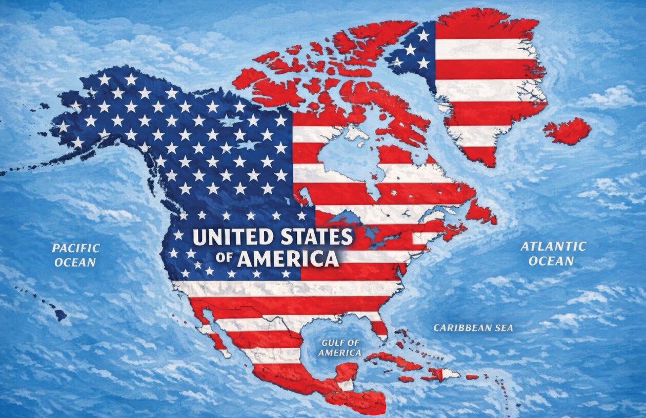
On Monday, President Donald Trump shared a controversial map on social media, depicting an expanded United States that includes much of North America. The AI-generated image, posted on Truth Social, features the U.S. flag over Canada, Mexico, Greenland, Cuba, and various other territories. The map lacks a caption or explanatory text, and the White House has not commented on whether it represents any formal policy proposal.
The image covers most of the North American continent, consisting of 23 sovereign nations by standard definition, alongside Greenland, an autonomous territory of Denmark, and several nations and territories in the Caribbean. The post aligns with Trump’s previous statements on redefining regional political boundaries. He has suggested in the past that Canada could become the 51st U.S. state and has shown interest in acquiring Greenland. Furthermore, Trump’s administration has increased diplomatic tensions with Mexico and Cuba.
In a response to Trump’s broader territorial ambitions, nations depicted on the map have voiced their opposition, even if not specifically reacting to the map shared on Monday. Canadian Prime Minister Mark Carney has consistently rejected the notion of Canada joining the U.S. During a meeting in the Oval Office on May 6, Carney expressed to Trump, “As you know from real estate, there are some places that are not for sale,” to which Trump replied, “Never say never.”
Mexico has also stood firm against U.S. pressure, with President Claudia Sheinbaum emphasizing Mexico’s sovereignty and independence. Sheinbaum stated on social media, “In the month of the homeland, we reaffirm that Mexico is neither nor will be a colony or protectorate of any foreign country. Proudly we are a free, independent, and sovereign nation.”
Similarly, Cuba has rejected Trump’s policies. Foreign Minister Bruno Rodríguez accused the U.S. of imposing “collective punishment” on Cubans, citing an energy blockade, intensified sanctions, and power shortages that have affected citizens significantly.
In addition to the map, Trump recently shared several AI-generated images, such as one suggesting New Mexico be renamed “New America” and another declaring, “The Moon Is Ours.” More earlier initiatives include an executive order signed by Trump to refer to the Gulf of Mexico as the “Gulf of America” by federal agencies, a change not internationally recognized.
Craig Agranoff, a political professor at Florida Atlantic University, commented on these creative displays during an interview with Newsweek. He noted, “This looks more like messaging than a policy memo. President Trump often uses maps and renamed landmarks as political theater.” Agranoff stressed the importance of not ignoring such gestures, warning that the image could impact diplomacy, trade, and security cooperation.
Countries depicted in Trump’s map include:
- Canada
- United States
- Greenland
- Iceland
- Mexico
- Belize
- Guatemala
- Honduras
- El Salvador
- Nicaragua
- Cuba
- Jamaica
- Haiti
- Dominican Republic
- Bahamas
- Puerto Rico
- Cayman Islands
- Antigua and Barbuda
- Saint Kitts and Nevis
- Dominica
- Saint Lucia
- Barbados
- Saint Vincent and the Grenadines
- Turks and Caicos Islands
- British Virgin Islands
- U.S. Virgin Islands
- Saint-Martin
- Sint Maarten
- Anguilla
- Saint Barthélemy
- Montserrat
- Guadeloupe
- Martinique
- Grenada